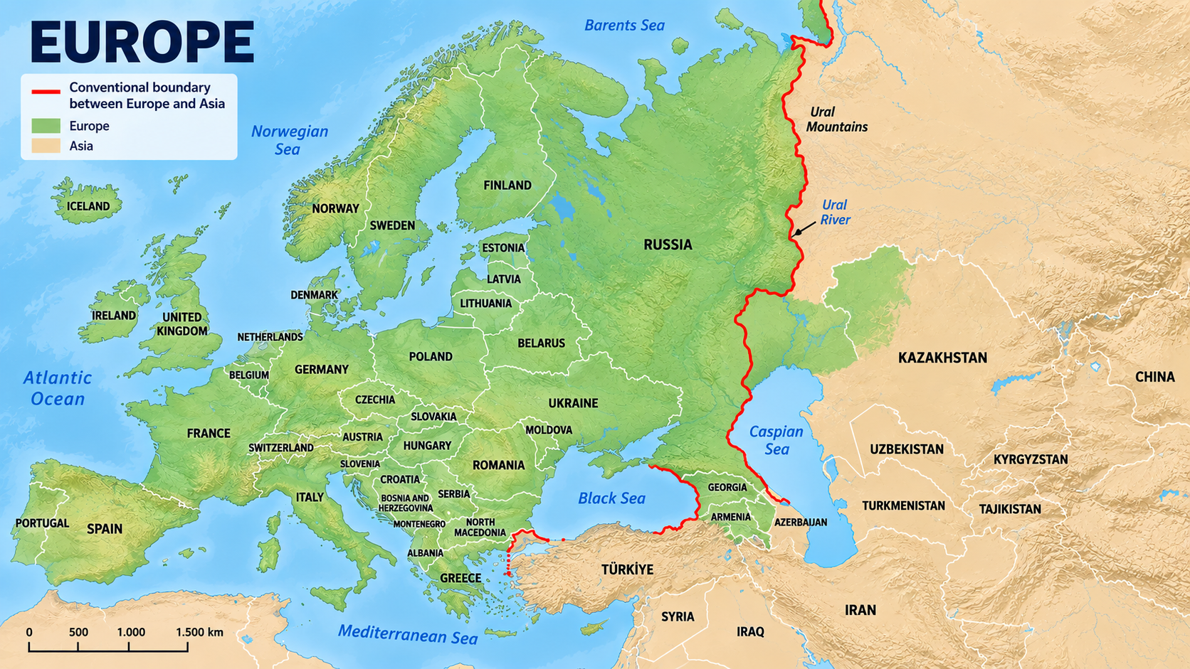
If you look at a map of Europe, the Atlantic lies to the west, the Mediterranean to the south, the Arctic Ocean to the north and the Ural Mountains to the east.
From a geographical perspective, Europe’s boundaries are relatively easy to define. But geography is only one perspective. Europe can also be understood through its historical, cultural and political boundaries.
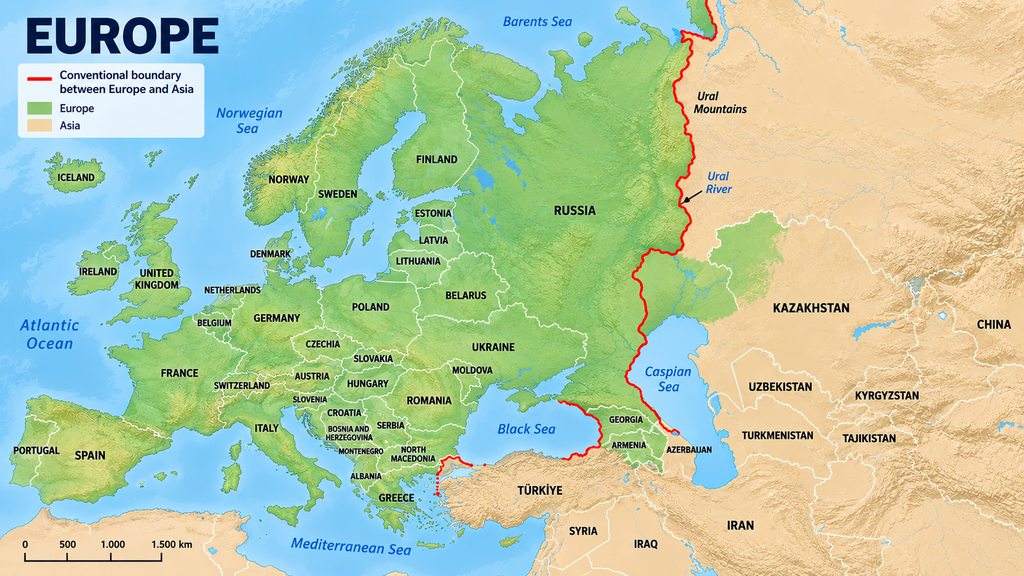
To the south, European territory reaches the African continent through Ceuta and Melilla, while the Canary Islands lie off the African coast.
To the west, even the apparently simple Atlantic boundary raises questions around Iceland and Greenland. Europe’s political connections are even beginning to extend towards Canada, including through growing cooperation around the Arctic.
To the east, the different definitions become particularly visible. Several countries lie across, or close to different definitions of, the boundary between Europe and Asia: Russia, Turkey, Kazakhstan, Azerbaijan and Armenia.
The conventional geographical border
Arctic Ocean → Ural Mountains → Ural River → Caspian Sea → Caucasus → Black Sea → Bosporus → Sea of Marmara → Dardanelles → Aegean Sea.
On a map, this looks like a clear and convincing geographical border.
The Ural Mountains are probably the least controversial part of Europe’s eastern boundary today. Running north-south through Russia for more than 2,000 kilometres, they provide an obvious physical feature to follow. European Russia lies to their west; Siberia lies to their east.
From the Urals to the Caspian
Mountains eventually end. Borders have to continue.
South of the Ural Mountains, the conventional boundary follows the Ural River through Russia and Kazakhstan until it reaches the Caspian Sea.
This creates an interesting consequence: part of Kazakhstan, west of the Ural River, can be regarded as geographically European.
The Caucasus: where the line becomes debatable
Between the Black Sea and the Caspian Sea rises the Caucasus, one of the most complicated sections of the Europe-Asia boundary.
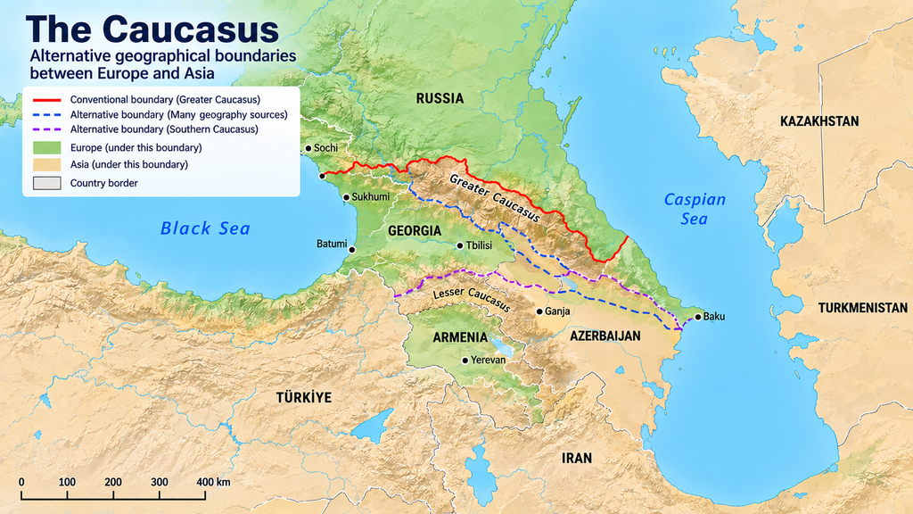
A commonly used modern convention follows the watershed of the Greater Caucasus, placing territory north of the main mountain crest in Europe and territory south of it in Asia.
But unlike the Urals, there is no universally obvious place to draw the line. Different geographical conventions have placed the boundary differently, which changes how parts of the Caucasus are classified.
This becomes particularly interesting when looking at Georgia, Armenia and Azerbaijan. All three are members of the Council of Europe, while geographically they sit directly around one of the most disputed parts of the Europe-Asia divide.
Russia and Kazakhstan: countries divided by the boundary
Russia is both European and Asian. Historically, it has even extended into North America.
But Russia’s size makes any simple continental classification problematic. Its territory has repeatedly changed through expansion, political decisions and wars. People living in different parts of Russia have very different neighbours, histories and geographical environments.
Western parts of today’s Russia have histories closely connected to Finland, Sweden and the rest of Europe. Other regions were shaped by the Mongol empires and the societies of Central and northern Asia. In the Far East, Russia also borders China, Korea and Japan and has a very different historical context from European Russia.
This makes Russia a special case. Instead of asking whether Russia as a whole is European or Asian, it can be more useful to look at its different regions and cities.
Russia developed in another direction. From its origins as a small city-state, it expanded through its alliance with the Mongol Empire, using that relationship both to survive as a vassal state and later to expand. When the Mongol Empire fell apart, Russia continued its expansion eastward across northern Asia. At its current extent, it connects European, Caucasian, Central Asian and northern Asian regions within the same political space.
Kazakhstan presents a smaller version of the same problem. Part of the country lies geographically in Europe, while most of its territory and much of its history are connected to Central Asia and the Mongol and Turkic worlds.
Where geography becomes more complicated
Turkey: Europe and Asia in one city
Turkey makes the continental divide impossible to ignore because the boundary runs directly through its territory.
Most of Turkey — Anatolia — lies in Asia. Eastern Thrace, including the European side of Istanbul, lies geographically in Europe. Between them are the Bosporus, Sea of Marmara and Dardanelles.
Stand beside the Bosporus in Istanbul and “Europe” and “Asia” are not abstract geographical concepts. They are opposite shores.
Geographically, Turkey is therefore transcontinental. Historically and politically, however, the picture is much richer than a line across Istanbul.
The territories of modern Turkey have been deeply involved in European history for millennia: ancient Greek settlements, the Roman and Byzantine empires, Constantinople, the Ottoman Empire and centuries of political, economic and military interaction with the rest of Europe.
Modern Türkiye has been a member of the Council of Europe since 1950. It applied to join the European Economic Community in 1987, became an EU candidate in 1999 and began accession negotiations in 2005. Those negotiations later reached an effective standstill.
None of this changes the physical geography of Anatolia. It demonstrates instead why the question “Is Turkey European?” cannot be answered simply by drawing the Bosporus on a map.
Geographically, the country is predominantly Asian and partly European. Historically, culturally and politically, it belongs to several overlapping worlds.
Cyprus: geographically Asian, politically European?
Cyprus presents an even more striking case.
The island lies in the eastern Mediterranean, south of Turkey and west of Syria and Lebanon. The United Nations statistical system places Cyprus in Western Asia.
Politically, however, Cyprus is firmly integrated into Europe. The Republic of Cyprus has belonged to the Council of Europe since 1961 and joined the European Union in 2004.
National Geographic, meanwhile, treats Cyprus as marking the southeastern extent of Europe, explicitly noting its historical and cultural ties to the continent and its EU membership.
Here the different definitions of Europe openly diverge.
Geographically, Cyprus can be placed in Western Asia. Politically, it is part of the European Union. Historically and culturally, the island has been shaped by Greek, Byzantine, Ottoman, British, Turkish and wider eastern Mediterranean influences.
Cyprus therefore demonstrates particularly clearly why geography alone cannot define where Europe ends.
Europe’s islands make the map stranger still
If the eastern border is complicated, Europe’s islands make its outer limits even less intuitive.
Iceland is normally considered European despite lying far out in the North Atlantic.
Then there are the Azores, Madeira and Canary Islands. The Azores and Madeira belong to Portugal, while the Canary Islands belong to Spain. All are integral parts of the European Union, although the Canary Islands lie just off the coast of north-west Africa.
And Europe’s political geography stretches much farther than that.
French Guiana is in South America. Guadeloupe and Martinique are in the Caribbean. Réunion and Mayotte are in the Indian Ocean. Yet all are integral parts of the European Union.
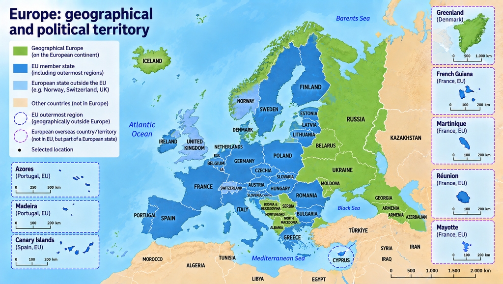
This produces an important distinction:
The territory of the European Union is not the same thing as the geographical territory of Europe.
Greenland demonstrates almost the reverse.
Geographically, Greenland is part of North America. Politically, it is an autonomous territory within the Kingdom of Denmark. Greenlanders are Danish nationals and therefore EU citizens, but Greenland itself is not part of the European Union.
So depending on whether we look at geography, sovereignty or political integration, we get three different maps of Europe.
Perhaps Europe has borders rather than a border
Geographically, Europe has a relatively clear boundary. The Atlantic, Mediterranean and Arctic form natural borders, while the Urals, Ural River, Caspian Sea, Caucasus, Black Sea and Turkish Straits provide a conventional boundary towards Asia.
But geography is only one way of defining Europe.
Once history, culture and politics are added, Europe’s boundaries extend in different directions. European states have controlled territories across the Atlantic, in Africa and Asia. Today, European political territory still extends far beyond geographical Europe, while places geographically close to or partly within Europe can have very different political relationships with it.
A geographical line cannot explain why Cyprus can be classified as Western Asian and simultaneously be an EU member state. It cannot fully capture Turkey’s position across two continents or settle the place of the Caucasus. Nor can it explain why islands off Africa, territories in the Caribbean and French Guiana in South America can be integral parts of the European Union while Greenland is not.
Europe therefore has several boundaries superimposed on one another: geographical, historical, cultural and political.
Understanding these different boundaries helps us understand how Europe reached its present shape. The more interesting question for the future is how we want Europe to develop — and where its boundaries should be.
Leave a Reply